STROMBOLI
Aeolian Islands, Italy (38.79°N, 15.21°E)
(This report covers the period September 1998 - June 1999)
After the strong summit explosions of 23 August and 8 September 1998 (Bulletin, v.23, no. 10), at least two other followed during 1998, the first one on 24 November, at 18:05 local time, the second one on 28 December, 2:45 local time. Fortunately, due to the season, these two eruptions did not threaten the safety of the tourists often visiting the summit during the summer months. Both were reported by Pierre Cottens from the village of Stromboli, with pyroclasts clearly seen from the village, reaching estimated heights of at least 700 metres over the craters for the first one, 500 metres for the second one, with little ash fall over Stromboli village, brought by the wind during the night. Both were reported on the Stromboli On Line "Special events" web page, http://stromboli.net. Unfortunately, due to technical problems, the seismic station operated by the University of Udine was not operational until the end of January 1999, so that these explosions were not recorded.
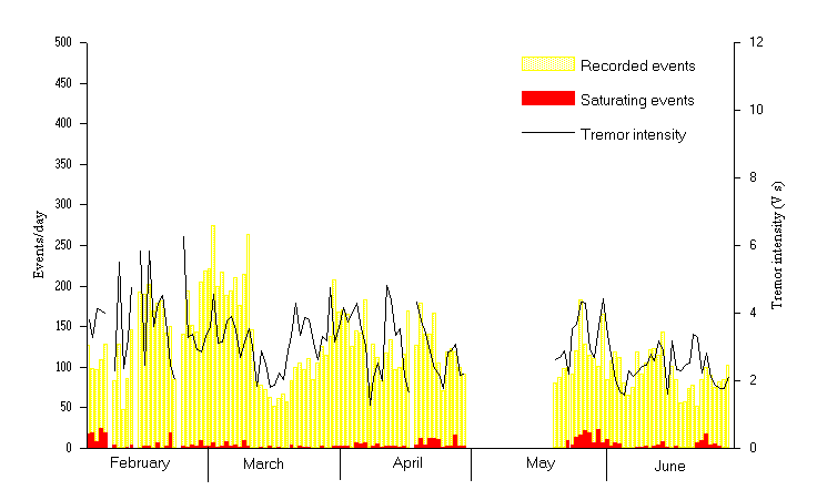
When the seismic station acquisition was restored on 1 February 1999, the daily number of events was decreasing, showing values declining from 130 to 50-80 events per day (Figure 1). The number of saturating events showed a similar trend. In contrast, the second half of February was characterized by an increasing number of events, reaching a local maximum of 275 events on 2 March 1999. During this period the tremor intensity showed fluctuations around an average value of 3.6 V.s, with an isolated peak on 23 February.
The middle of March (12 to 20) showed a general decrease of
IN the activity, with a minimum number of 52 seismic events recorded
on 16 March, and a minimum tremor intensity of 1.8 V.s on 15 March.
The reprise of the activity was observed first on the tremor intensity
parameter, with a local maximum of 4.7 V.s on 29 March, then in
the number of events, which reached a new local maximum of 208
events on 30 March.
A sharp decrease was observed on 7 April both in the tremor intensity (from 3.0 to 1.2) and in the number of events (from 180 to 76). Also the number of saturating events declined to 0, compared with an average of 5 saturated events during the three preceding days. After a slight increase in the seismic activity during the following two days, on 9 April Pierre Cottens reported two strong blasts in the night, separated by a few minutes. These occurred around 3:00 am local time. Bad weather did not allow any direct visual observation of the summit area, but the noise was almost comparable to the one produced by the strong eruptions of 1998. Our seismic station recorded an event with an energy greater than usual, that could be the seismic footprint of one of the explosions. A new decrease of the activity was observed the day after the strong eruption, with the number of events again decreasing to 83 and the tremor intensity to 1.9. The following days were characterized by a slow increase, but the activity remained at a low to moderate level for the rest of the month.
After another gap in the acquisition, the activity was still at a low level after mid May 1999, with a daily number of events constantly below 100 between 20 and 24 May. The last week of May showed an increase in the number of events (with a local maximum of 183 events on 26 May). A relatively high number of saturating events was also observed, starting 23 May and peaking on 27 May (21 saturating events) and 30 May (23 saturating events). Another minimum in THE number of events (66), number of saturating events (0) and tremor intensity (1.6) was recorded on 5-6 June 1999.
We spent several days on the island during the second half of
June, and during this period the seismic activity remained at
low to moderate levels, with a short duration increase in the
tremor intensity on 21-22 June. During 4 days of observations
between 17 and 20 June, viewing conditions were suitable to view
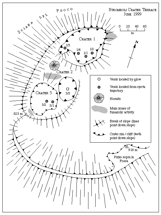
and map the crater terrace on 18 and 19 June (Figure 1
2). We made detailed activity observations over two 3-4 hour
long periods: (1) 21:09-01:00 (18-19 June), and (2) 20:30-23:20
(19 June).
Crater 1 was the location of 4 active vents (Figure 1
2). During the first observation period, although the vicinity
of vent 1/2 was the source of persistent and widespread glow,
no ejecta was observed from this source. Vent 1/1, however, was
the source of glow and near-persistent, low energy activity.
This was characterized by periods during which repeated phases
of ejecta emission occurred, separated by periods of no or rare
emission. Each phase consisted of numerous pulses of ejecta emission.
During each pulse a few (typically 1-10) bombs were ejected to
heights just exceeding (by <10 m) the crater rim, with pulses
occurring every few seconds. Around 11 periods of such persistent,
pulsing emission were observed. Each period lasted 2-29 minutes
and was separated by 3-28 minute-long periods when only occasional
bomb emissions were observed. This pattern of activity at vent
1/1 was broken by 16 high energy events during which explosions
sent shells of ejecta to heights of ~100 m. Vent 1/3 was characterized
by high energy events only, where 18 occurred during the first
4-hour-long observation period. High energy events from vents
1/1 and 1/3, and also from a third vent (1/4), were synchronized.
It was difficult to distinguish eruptions from 1/4 and 1/1 from
our viewing angle, therefore eruptions from these two vents may
have been assigned to the wrong vent on occasion. We therefore
consider our eruption counts for 1/1 and 1/4 together. Vents
1/3, 1/1 and/or 1/4 erupted together on 11 occasions. On these
occasions ejection from each vent was either (1) synchronous or
(2) closely linked, where an eruption from one vent would be followed
by eruption from another within a second of the first erupting.
During such synchronized events there appeared to be no set order
in terms of which of the three vents started erupting and which
followed. Vents 1/1 (and/or 1/4) and 1/3 erupted on their own
on 5 and 7 occasions, respectively.
As in the first observation period glow persisted above vent 1/2 throughout the second period. Unlike the previous evening, however, ejecta was observed from vent 1/2, where activity followed the style observed at vent 1/1 during the previous evening. Around 8 periods of low energy but persistent, pulsing, activity were observed. These lasted 3-33 minutes and were separated by 2-23 minute-long periods of apparently no emission. This pattern of activity from vent 1/2 was interrupted by 5 high energy events, lasting 4-6 seconds. Although regular gas puffs (typically 1 puff every 1-2 seconds) issued from vent 1/1, the frequency of ejecta emission had declined, with the periods of persistent, pulsing activity observed during the previous evening replaced by discrete emissions. Ejections were observed from 1/1 on 9 occasions, where only 1 event was of the high energy type, and the remainder were short (<40-second-long) periods during which 1-10 bombs were ejected <10 m above the rim in pulses. Again, vent 1/3 was characterized by high energy events only, with 7 occurring over this second 3-hour-long observation period, of which 3 were synchronized with high energy events from 1/2 or 1/1.
Although no activity or glow was observed from Crater 2, a hornito had built in the vicinity of the low cone observed during May 1997 (Bulletin v. 22, n. 5). The surrounding Crater 2 doesn't seem to be marked by any crater-like feature anymore.
The subsidence bowl observed to the S.E. of Crater 2 in May 1997 (Bulletin v. 22, n. 5) had developed into a deep, funnel-shaped pit, which was the source of faint glow (Figure 2). In the map given in Bulletin v. 22, n. 5 the vent numbering indicated that this area was part of Crater 2. This interpretation is questionable and this feature could be even considered a crater by itself now. We prefer, however, to denote again this vent as 3/3, therefore part of Crater 3, in order to allow for an easy comparison with older maps of the crater terrace (e.g. Bulletin, v. 22, n.3).
Crater 3 was the location of 2 additional active vents (Figure 2). Glow was observed from vent 3/1 only after an eruption which occurred at 23:17 on 18 June. Eruptions from Crater 3 were of the high energy type only, and were typically larger (in terms of volume and height, attaining heights of 150±50 m) and longer (lasting 8-23 seconds) than those from Crater 1. Nine and eleven eruptions occurred from Crater 3 during the 2 observation periods respectively.
During our descent in the early hours of 19 June we experienced a large rock fall/slide. This occurred at ~02:00 and lasted 1-2 minutes. During this time large boulders from the cliffs on the northern edge of the Rina Grande rolled and bounced at speed down the Rina Grande. Owing to the steepness of this flank, once in motion the rocks probably did not stop until they reached the sea in the direction of Forgia Vecchia, crossing the path which descends the Rina Grande ash slope within seconds of the rock fall beginning. Such events pose a very serious hazard to anyone using this route. We thus urge caution when traversing the Rina Grande, especially at night, as in this case, as only the sound can be used to guess the trajectories of the rocks and avoid them.
Fig 1. caption:
Seismicity recorded at Stromboli during 1999.
open bars = number of recorded events per day
solid bars = saturating events, i.e. with ground velocity exceeding 100 µm/s
line = daily average of tremor intensity on hourly 60-seconds samples.
Fig 2. caption:
Sketch map of Stromboli's Crater Terrace drawn on 18-19 June 1999 from Pizzo sopra la Fossa and fitted to the map produced from our September 1995 EDM survey of the Crater Terrace (Bulletin v. 20, n. 11/12).
Information contacts:
Andy HARRIS and Dawn PIRIE
Department of Earth Sciences, The Open University
Milton Keynes, MK7 6AA, U.K.
Email: a.j.l.harris@open.ac.uk, d.j.pirie@open.ac.uk
Fax: +44 (0)1908 655151
Tel: +44 (0)1908 654296
Sarah SHERMAN
41-485D Kalanianaole Hwy., Waimanolo, Hawaii 96795, USA
Email: macbeanur@yahoo.com
Roberto CARNIEL
Dipartimento di Georisorse e Territorio, Università di Udine
Via Cotonificio, 114
I-33100 UDINE
E-mail carniel@dgt.uniud.it
STROMBOLI ON-LINE website:
http://stromboli.net